Best Satellite Imagery Aggregators for GIS Work

Buying satellite imagery has stopped being a procurement exercise and become an integration one. The question is no longer which sensor to order from, but which platform to build against, and those are different decisions with different failure modes.
How this list was ranked
The order below is not this site's judgment. It reproduces the ranking published in a comparison of satellite imagery aggregators, according to this website, which scored eight platforms on modality coverage, self-serve ordering, pricing transparency, and tasking. The top five appear here with the detail a developer needs added to each: how orders are placed, how authentication works, and what the billing unit is.
Anyone wiring imagery into a processing chain cares about a different set of attributes than a procurement officer does, and that set is rarely published side by side.
What a STAC badge actually covers
One misconception is worth clearing before the list. The SpatioTemporal Asset Catalog is a discovery specification, ratified as an OGC Community Standard, with core at 1.1.0 and the API at 1.0.0. It defines how a catalog describes and exposes items, and it defines a search endpoint.
It does not define ordering, delivery, or authentication. Eight platforms advertising STAC compliance means one client can search all eight, and it means nothing beyond that moment once a scene is found. Every step after discovery is proprietary, which is exactly where integration effort accumulates.
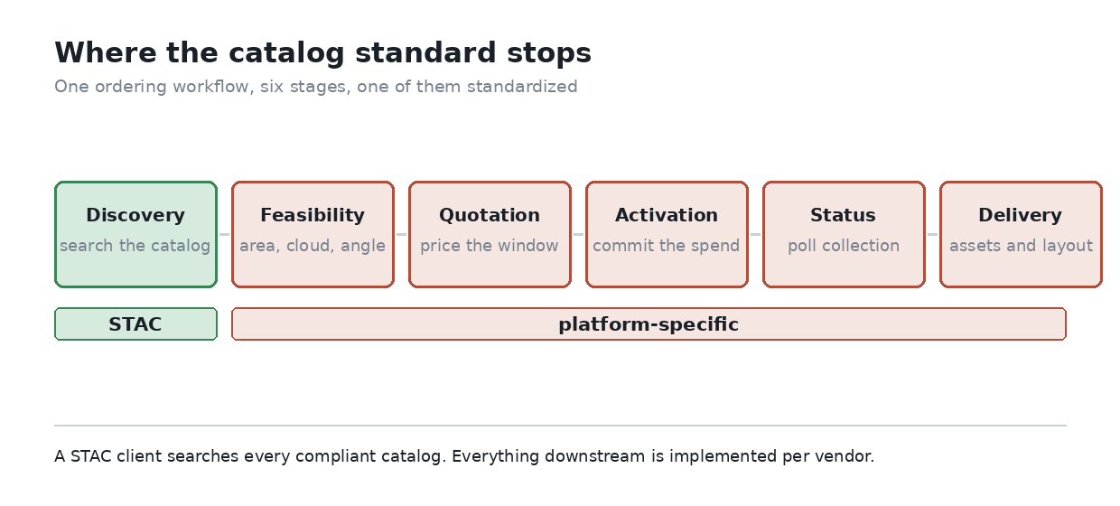
Where the standard stops. Discovery is common across platforms, and everything downstream of it is implemented per vendor. Source: own diagram, following the STAC specification scope published by OGC.
With that boundary in mind, the five platforms below are worth reading as five different integration surfaces rather than five storefronts.
The five satellite imagery aggregator platforms
Each entry keeps the position from the source comparison and adds the ordering path, the authentication pattern, and the billing unit, which are the three that decide how much glue code a project needs.
1. Sfera Technologies
Ranked first on modality coverage: optical, SAR, thermal, and hyperspectral, plus RF and ELINT collection, which no other platform in the comparison brokers. Ordering runs through a web application with an API alongside it, and the pitch is breadth of source rather than depth of tooling. For a GIS shop, the practical draw is getting a non-optical modality without a separate contract.
2. SkyFi
The most self-serve option in the set. Pricing is visible before checkout for a given sensor, resolution, and area, payment is by card, and there is no contract or minimum spend. A REST API exists, though the web and mobile paths dominate. Useful for one-off acquisitions where the overhead of a procurement cycle exceeds the price of the scene.
3. UP42
The most developer-shaped platform here: REST API, a documented Python SDK, role-based access control, and STAC-compatible delivery. Billing runs on credits that expire after twenty-four months, are consumed first-in-first-out, and are non-refundable, which makes them a budgeting artifact rather than a simple prepayment. One correction worth carrying: UP42 has been owned by NSG since July 10, 2025, and is no longer an Airbus subsidiary, a detail still miscited across a good deal of documentation.
4. SkyWatch
The GIS-native option, with the closest integration into desktop workflows and a discovery layer spanning several hundred sensors. The self-serve product is pay-as-you-use with no subscription, and a separate build product exposes a REST API and SDK for teams that want the catalog behind their own interface.
5. Sentinel Hub
Different in kind from the four above, and the one most likely to already be in a QGIS user's stack. It is an archive and processing service rather than a tasking broker, with a Process API, a Batch API, and a STAC-compatible Catalog API, alongside a dashboard and a request builder for work that does not need code. Authentication is OAuth client based, with client counts tiered by plan, and billing runs on Processing Units computed from output pixels, band count, and output format. Anyone running large time series should model the PU cost first, because the formula rewards careful request design.
|
Platform |
Ordering path |
Auth pattern |
Billing unit |
|
Sfera Technologies |
Web application plus API |
Account based |
Per order |
|
SkyFi |
Self-serve checkout |
Account, API key |
Per scene, card payment |
|
UP42 |
API, SDK, or console |
API with RBAC |
Credits, 24-month expiry, FIFO |
|
SkyWatch |
Self-serve or API |
Account, API key |
Pay-as-you-use, usage tiers |
|
Sentinel Hub |
API, dashboard, request builder |
OAuth clients, tiered by plan |
Processing Units |
Four billing units across five platforms is the part that resists abstraction, and a cost model rarely ports from one to the next.
What happens after discovery
Tasking a new collection follows the same five-step shape almost everywhere, and none of it is covered by the catalog standard. A client that only knows how to search will stall at the second step.
· A feasibility check tests the area, cloud constraints, and look angle, and a demanding request can come back with nothing
· A quotation prices the accepted feasibility window, and prices are not stable across platforms for the same upstream sensor
· Order activation commits the spend, and this is where credit and card models diverge
· Status polling covers the collection window, and polling intervals differ by platform
· Delivery hands over the asset, in formats and directory layouts that are specified by the vendor rather than by the standard
Building against two platforms means implementing that sequence twice. The search half is shared, and it is the smaller half.
The licensing ceiling
An aggregator cannot grant more than its upstream supplier granted it. Its terms of service are a ceiling rather than a floor, and the most restrictive applicable license governs use of a scene even when the platform's own tier name suggests something broader.
Tier names in particular do not transfer. A "standard" license on one platform is not the same grant as a "standard" license on another, and neither necessarily matches the provider's own tier of that name. For anything that ends up redistributed, published, or embedded in a deliverable to a client, the provider end-user agreement is the document to read, not the platform's summary of it.
Picking one
Modality coverage decides the shortlist and integration shape decides the winner. A team whose processing chains descend from the toolbox documented here, long since absorbed into the Processing framework in QGIS core, will find Sentinel Hub the shortest path for archive work, and will find that tasking needs one of the other four regardless.
The comparison behind this ranking scored on procurement criteria, which is the right frame for most buyers. For a developer the ordering worth keeping is a different one: how much code sits between a search result and a file on disk, and whether that code has to be written twice.